I woke up at 2:30 am Friday morning and struggled internally, trying to decide whether I really wanted to get out of bed or not. It was the Day 1 of the Sierra Challenge and although I didn’t want to miss the start, I had found that last year I often ended up hiking solo despite starting with the group. Perhaps most relevant to my debate was the fact I had only gotten to sleep at 1:15 am. After a minute of looking at the estimated drive time I finally wrenched myself out of bed and hit the road.
The day’s hike started out of the Green Creek Trailhead, just south of Bridgeport and after two and a half hours of driving, I arrived at 5:50. I had intended to have breakfast at the trailhead before the start, but I had no time for that. I threw my gear into my pack, locked the car and hustled over to the trailhead in my flip flops, trailrunners in hand. I shouted for Bob to wait as he was about to snap the starting photo and I rushed over, noticing lots of friendly faces I hadn’t seen in a while! The group headed off somewhat sluggishly and I found a rock to sit on and lace up my shoes.

I managed to catch up to the back of the group, quickly stuffing a granola bar in my face as I hiked, and we were off along the Green Creek trail. The trail was nice and conversation made the miles pass quickly. We arrived at Green Lake and took the fork toward West Lake where the trail started to climb more steeply.

I was ahead of Tom, Iris, and Bob and soon realized that I my pace was starting to slow, so I stepped aside to let them pass. This hike wouldn’t be a huge effort, but it would dictate the rest of the Challenge. If I overworked myself on day one, the consequences would compound over the following days and I’d have no chance of making it to Day 10.

The trail crested a small rise and I found myself at Bergona Lake. 100 ft ahead of me I spied the group stopped and talking with two other hikers. I left the trail and headed toward them, following a faint use trail through the talus along the north side of the lake.

After five minutes I was surprised to see that the group had stopped near the lake. It seemed too early for them to be filling up water but perhaps they were having an early lunch. As I climbed the loose talus toward Tamarack Peak, I glanced back and saw that Tom had pulled his shirt off. Of course – they were swimming! I hooted my approval down to them and Chris entreated me to join. A swim sounded nice, but I was already several hundred feet above them and not eager to waste my effort.

Bob and the other two hikers had opted to take a route up a steep gully where the rock looked incredibly loose. Not only would this be unpleasant climbing, but I definitely did not want to follow in the path of rockslides they would inevitably trigger. Instead I climbed the solid rock to the right of the gully and found it to be quite pleasant. It had its share of loose boulders, but overall it was fun climbing and every time I heard the hikers in the gully let loose another rock, I felt validated in my choice.

I arrived at the top of the gully and crossed from my solid rock toward the saddle between Tamarack and Bergona Lake Peaks. I was confused as to where the three ahead of me had disappeared to, but eventually I spotted the two hikers heading much further left across the slope. I was happy with my route so I continued uphill.
I arrived at the saddle and was dismayed to find that this wasn’t actually the saddle. Instead, I was about halfway up Tamarack Peak from the saddle. I considered climbing Tamarack before heading over to the Challenge Peak but Tamarack looked very steep and uninviting above me. I wasn’t too distraught over my decision to skip the peak. Damage control was the name of the day’s game, anyway!

As I hiked down to the saddle, I was elated to see Mason coming down the peak. Apparently he had gotten a 5:15 am start from Twin Lakes which explained why I hadn’t seen him! I stopped to talk with him for a bit and Bob, who had just climbed Tamarack, joined us. Mason continued down the mountain, in a hurry to make it to Tahoe later tonight, and Bob and I climbed onwards, arriving at the summit at 9:15 am.
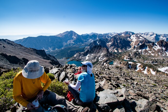
From the summit, the view of the Sawtooth Range was foreign, but after some study I recognized Matterhorn Peak’s summit and the jagged profile of Sawtooth Ridge. Twin Peaks, which looked so nearby on the map was separated from our perch by a severe ridgeline.

The views in all directions were spectacular and for the first time, I was able to identify all of the major summits (as well as a few minor summits in the Cathedral Crest)!


Everyone signed the register and seemed content to enjoy the company and the summit. I had the remainder of what scant food I’d packed as we waited for the stragglers to join. I was surprised that Kristine and Rob were the last to join us (we spotted Scott atop Tamarack, but I left before he made it over).
Bob asked me where I was headed and I told him I figured I head back the way I’d come. It wasn’t pleasant climbing, but the steep talus would make a quick descent and since I was operating on an hour of sleep, two granola bars, and a few fruit snacks, I figured it wasn’t the time to explore all the nearby peaks. He seemed disappointed with my answer and surveyed the rest of the group. Clement and Bob pointed out a ridge which led to the far side of Bergona Lake and decided to strike off that way. After some consideration, I realized this route would be much more interesting and probably wouldn’t be too much extra effort, so I decided to follow along, although I wasn’t planning to summit any other peaks.

The route toward the ridge looked precipitous from the summit, but as Clement and I hiked, we found that it was easy enough. If the ridge weren’t littered with so much loose rock, it might be fun! Alas, eventually the littered ridge gave way to yet more loose talus.

The heather grew in remarkably dense patches and was in peak bloom. Last year, I distinctly recall that all of the heather was already in seed during the Challenge despite some very late rainstorms. It seems the heavy snows pushed spring back by several weeks this year! I kept pace with Bob and Clement on the descent, but eventually they pulled ahead while I was taking some photos.

I caught up with and passed them while they stopped to fill up water at a small tarn, but soon I spotted them above me on the ridge. I traversed the ridge and descended toward a large lake which I assumed to be Green Lake. I was a bit disoriented by how large many of the lakes in the basin were and after some confusion I realized that I was actually at Par Value Lakes.

As I approached the shore of the largest lake, I encountered the first mosquitos of the day, swarming in groups along the shore, but as I walked through several swarms, they mercifully seemed uninterested in me and I didn’t notice any stalkers. I followed the outlet of this lake, hoping to find a reasonable cross country route which would allow me to regain the trail at Green Lake.

I quickly picked up a good use trail which followed the creek for half a mile before dissolving atop a steep talus pile. Luckily this talus was more secure than the slope above Bergona Lake, but an old foot injury was aching and I was starting to get worried that I might not make it to day 2. Soon I spotted a trail below me and was happy to be on the easy path out.
The trail descended toward Green Lake through dense forest which grew thick with wildflowers. I was frequently stopping to take photos, but wished that my foot was feeling better so that I could jog, both because of the high quality of the trail and the aggressive mosquitos.


The trail grew very swampy along the northwest corner of Green Lake and after dunking both feet in the soft mud, I eventually gave up any attempt to stay dry, instead wading through the muck and overtopped creeks.

I met up with the main trail and made swift progress back toward the trailhead. I took a slightly different route back, following a forest service road and was surprised to find numerous cabins nestled in the woods. I arrived back at the trailhead a little after noon and thought there was a chance I might be the first back for the day. Of course this was not my goal, and I was a bit disappointed that I didn’t have more gas in the tank to start off on a strong note, either with a more competitive time or more summits. Regardless, I was glad to be off the trail.

I headed back to Bridgeport for lunch before heading to Mammoth to find a spot to camp for the night. I would have liked to catch up with everyone for dinner, but I was so exhausted I ended up falling asleep at three and sleeping through the night.
GPS Data
Elevation Gain: 4,300 ft