Rafee and I met for dinner Saturday night in Visalia before heading to the South Fork Campground at the far southwest corner of Sequoia National Park. The majority of the road was in poor condition and I was very glad that I’d decided not to make the journey using the space saver tire — even with four full size tires, it was slow going and I caught myself holding my breath through several tricky sections. We eventually made it to the campground without issue and agreed to start hiking by 6:45 before heading to sleep.
I slept poorly and was constantly woken up by nightmares. Rafee had invited me on the trip about a month prior, hyping it up as a “classic Sierra bushwack,” and “going to be pretty crappy; not going to sugarcoat it.” We were hoping that by attempting the climb so early in the year, it would merely prove to be a “crappy” bushwack and not a “sweltering, mosquito ridden, poison oak infested” bushwack. Such an early season start meant that we were likely to encounter snow, although we had no real idea how high the snowline was or how deep the snow would be. I wasn’t able to wrangle any snowshoes and was planning to bring my skis, which would be less than optimal for a bushwack. My dreams seemed to alternate between a surprise snowstorm which brought more than a foot of snow to the camp at 3,800 ft and hiking all the way to the summit with my skis without once encountering snow.

We managed to wake up at six, but due to my poor sleep, some stomach discomfort, and being out of practice at early morning starts from the car we didn’t hit the trail until nearly 7:30. Rafee was patient and even insisted on a “before” photo with the trailhead sign. The trail quickly crossed to the north side of the namesake South Fork Kaweah River and we followed it at pace. After about half an hour, Rafee realized that we’d hiked past our turn off and we backtracked about half a mile to Pigeon Creek.

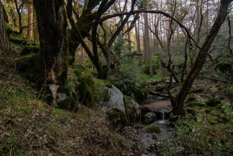
We turned right up the Pigeon Creek drainage which was incredibly lush. The tiny creek was lined with live oaks and, judging by the abundance of rotting nuts, chestnut trees not yet in leaf. Moss grew thick on the oak and rocks and some small wildflowers grew where they could find sunlight. Now that we were off trail, we were cautiously eying each shrub, hoping that we wouldn’t stumble into any poison oak which was supposed to grow thick in this drainage. As it turns out, we did not encounter any poison oak along the entire hike (UPDATE: as of April 4th, we definitely walked through poison oak, though this is the most minor case I’ve ever had). Dennison Mountain rose across the South Fork Kaweah and I was a bit concerned by how meager the snow appeared — only the steepest, most protected northern aspects continued to hold snow. If this was any indication, we might not hit snow until seven or eight thousand feet.

The valley widened a bit, the oaks grew denser, and the moss deeper. Every couple hundred feet a massive boulder would lay in the throat of the valley, blocking the creek and creating a beautiful cascade. We eventually came to one boulder which stood easily 50 feet tall and I remarked at it. Rafee realized that this was a landmark on the route we were following and found a fire circle built in its shelter.

As we hiked higher, cedar saplings began to grow along the route, and spindly young cedars rose tall, but mostly appeared dead. Looking up to the ridge, I could see that entire cedar forests grew on either ridge although all of the trees seemed dead.

After climbing one particular waterfall, the entire forest suddenly transitioned to zombie cedars and the sunlight filtered through the toothpicks providing a magical light. Rafee and I agreed that it felt as if we’d just stumbled into Rivendell!
Soon Rafee announced that it was time to leave the creek and start the climb up the west slope of the valley. I spotted a use trail heading up the west bank and we followed it straight into a thicket. We were confident that we were in the right area, so despite the dense brush, we fought through it and eventually found ourselves on a grassy slope lined by oaks and chestnuts.

In the last two hours, thanks to the tricky routefinding and fairly complex terrain, we’d only covered 2 miles and gained about 1,000 feet of elevation. Finally this opening allowed us to make some progress, quickly gaining 1,000 feet across the field. This field also afforded us our first view of Homer’s Nose (although we later found out that what we’d assumed was Homer’s Nose was in face Homer’s Brow)! Worried that I might not be able to get any skiing in, I told Rafee that if there wasn’t any snow on the route, I’d ski down this slope — it would even make a pretty cool shot with Homer’s Nose in the background! I’ve never seriously tried skiing down grass, but it seemed like the perfect slope, and mostly free of rocks!

The field ended all too soon, and another heinous bushwack awaited us at the top.

Luckily, the ridge ahead of us wasn’t a tangle of bushes and we found it to be easy travel. Along the way, I spotted hundreds of irises working their way out of the ground — in a couple weeks, this forest would be enchanting!
At the end of the ridge I was inclined to continue straight up the hill, but Rafee insisted that his reading of trip reports indicated the importance of finding an old trail which had fallen into disrepair. I was just about ready to give up looking for it when we finally spotted it. Rafee knew it as the “Manzanita Traverse” and we found the name to be accurate. Rafee led the way on the traverse and he frequently disappeared into the dense manzanita. I had to constantly reach up and guide my skis through the brush lest they snag a branch and stop me in my tracks.

The next landmark on the route was the “Blasted Part of the Manzanita Traverse” and we hypothesized what exactly “blasted” might mean. I expected, being used to cursing at manzanita, that it was probably meant as a curse. Rafee guessed that it was perhaps a section of sun or sand-withered manzanita. Neither of us guessed at the truth, which was evidence that some real effort at forming a trail was expended in the past — the rock was clearly blasted to form a beautiful level trail and there were several iron rods reinforcing the rock below! This was probably the only section anywhere along our hike where we were able to make more than one full step at a time!

The traverse continued a while longer through denser manzanita before entering a pine forest. Here the trail was still easy to find, but numerous downed trees meant having to frequently detour twenty feet up or down before regaining the trail. Now that we were on a more westerly aspect, snow occasionally dotted the trail as well. Around noon we reached Surprise Camp along Bennett Creek. We stopped for a bite to eat and Rafee asked if I wanted to ditch my skis. I considered it briefly, but it seemed like the worst of the bushwack was over. As much as I’d like to lighten my load by 10 pounds, the majority of the effort to bring skis had already been spent bushwacking to this point so I decided to keep them.

We found a trail which led out of Surprise Camp, but it soon disappeared and we began heading uphill toward Salt Creek Ridge. We found easy travel along the top of a ridge, but we were concerned that we might soon meet at an impassable cliff, so we gradually traversed west as the slope grew steeper above.

Patches of snow grew more frequent and I led the way up the slope (mostly because Rafee was the faster of us and would probably drop me if he traveled ahead). After a while we traded leads and Rafee took a turn breaking trail. Now that my focus wasn’t consumed with setting the bootpack, I realized that we were doing an awful lot of travel across snow, and above us on either side, the terrain looked to be completely covered with snow. I told Rafee that I was going to don my skis. He was unconvinced that it would be worth it, but by the time I had my skis on, Rafee had equipped his snowshoes.

We were both immediately struck by how much easier the travel became without sinking 5 inches into the snow with every step! We encountered one short snowless section where I had to take my skis off for thirty feet, but the rest of the trip to the ridge was fairly easy.

We gained Salt Creek Ridge around 2 pm and realized that we were way behind schedule. We’d discussed turning around at two but now that we were so high on the climb with the worst bushwacking behind (and also ahead of) us, we were willing to push a bit later with the understanding that we’d be returning in the dark. We decided on a 3 pm turnaround, though we later delayed it again to 4 pm. We stayed high on the ridge, occasionally avoiding small local highpoints and rocky sections. Lots of interesting granite features lined the ridge, likely the origin of the massive boulders along Pigeon Creek below.

At one point, I took a route which involved jumping three feet off of a rock onto the snow. I looked back and apologized to Rafee for choosing such a poor route and was surprised with how happy he was. It turned out he was happy for having found a cairn — we were on the trail! I chastised him for being excited about a cairn which defiled the natural state of our surroundings and convinced him that he should knock it over. He knocked over the top rock and managed to cut himself — deciding that perhaps the rest of the cairn should be left.

Rafee was concerned about possible avalanche danger and we discussed the hazard, eventually deciding that the slope wasn’t steep enough to be dangerous but agreed to stay vigilant. A little while later we found a massive pinwheel, 1 foot wide and nearly 6 feet in diameter!

Soon we reached what appeared to be the final climb to the summit and Rafee took off ahead of me, eager to start the descent and realizing that I would easily catch up to him on the downhill.

I caught up with Rafee at the summit just before 4 pm and I could tell how relieved Rafee was — he had genuinely doubted that we would make the summit. I had never doubted a summit, although perhaps I should have. The view from the summit was stunning, especially the view of the Kaweahs to the northeast!

Rafee hurried off to another highpoint nearby which might be the official “Homer’s Nose” and I stuck around enjoying lunch and taking in the view.

Clouds popped in and out of existence among the high peaks. To the south, a more persistent and darker cloud hung over Mt Dennison.

After finishing my lunch I headed over to the other high point. A steep canyon separated it from the first and Homer’s Brow was further yet. I was disappointed that we didn’t have time for a visit because it is such a beautiful formation! I snapped a few photos from this highpoint before following Rafee’s track back toward the ridge.

Now at the top of the descent, I ripped my skins and was glad to start the easy journey downhill — this wasn’t exhilarating skiing, but it was much better than downhill snowshoeing. I had eyed a small open stretch of snow on the way up and was ecstatic to link a few turns down this pitch!

I was impressed by how much ground Rafee had covered in the twenty minutes between each of our departures and once I caught up, I kept my distance ahead of him, as I had to occasionally maneuver uphill, which is a bit more difficult on skis than snowshoes. I was glad that he was a bit slower than me, because it afforded a few chances to peek north to prominent features in Sequoia.

Moro Rock. The forest beyond contains the largest trees in the world! 
Mt Silliman. 
Castle Rocks; Alta Peak, beyond. 
Future ski descents on the Great Western Divide?
Rafee continued to keep good pace and I was impressed by his standing glissade, although he admitted that he’d rather be skiing.

We headed down off the ridge, trying to stick to the snowiest sections which were most easily traveled eventually we found ourselves atop several large rocks without an obvious snow route and with less than adequate snow coverage below. I descended as far as I could before admitting that it was time to remove my skis.

We found ourselves in a different drainage from the one we’d climbed and stopped at our first opportunity to fill our empty water bottles. It was starting to get chilly and we had only half an hour to find our way back to the manzanita traverse before sunset, so we didn’t stop long, despite the beautiful forest around us.

We continued along as fast as possible occasionally picking up and losing the trail. It was around this point that I gave up announcing when I’d find a trail — the pattern all day long was “Oh hey! A trail! … Oh … Nevermind …” Nonetheless we did manage to find the traverse and we got about halfway across it before darkness set in and we donned our headlamps. The trail which we’d found so easily navigable by daylight now befuddled us. On two occasions, we were convinced we’d lost the trail entirely before taking a second look and realizing that it, in fact, continued straight ahead of us. Making matters worse, the thicket now brushed against the new scratches I’d earned on the ascent and felt all the more painful.

We managed to make it off of the “Manzanita Traverse” onto the lower ridge before twilight ended and found that a trail continued along the ridge. At first we marveled at how easy this trail was but soon we’d lost it. Rafee suggested that we needed to head uphill a bit to pick it up again. Uphill was dense brush, but in my stubbornness I decided to dive right into it. Unfortunately, with headlamps it was impossible to tell whether there was three feet of thicket followed by a clearing, or if the thicket went on forever. I dove literally head first into the thicket, often crawling on hands and knees. After a few feet, I realized incredulously that Rafee had followed me into this rat’s nest! I struggled onward, but was completely ensnared, thanks to high profile of my skis. I tried to back up but found I was completely stuck! Luckily Rafee was able to extricate my skis and I struggled forward another ten feet before arriving in a less dense section which was obviously part of an overgrown trail. Rafee seemed to have expected this outcome, but I was pretty unhappy with the situation and resolved to not blindly stagger into any more bushes.

We eventually found our way to the clearing and I hailed it as an indication that the end was near! It was 9 pm and I guess that the remaining two miles should only take an hour. Rafee guessed that it would be midnight by the time we returned and said he’d be ecstatic if we returned by 11. He was obviously dispirited and I tried my best to keep the mood light, though I also found the descent frustrating at times.

We descended back to Pigeon Creek quickly and managed to avoid the thicket we’d found on the way up. Travel along the creek started off fairly easy but as we traveled lower we found many more boulders and waterfalls than we’d remembered climbing past on the way up. At one of the last major waterfalls, we couldn’t remember how we’d come up and we couldn’t find a safe route down so we ended up making a wide traverse to the east.
Finally, we rejoined the trail and in ten minutes we were back at the car, exhausted and bloody, but happy to have made it back by 10:30 pm! We dropped our packs, and enthusiastically recounted the trials of the day, not caring whether we might wake someone sleeping in the other car at the trailhead. I had frequently told Rafee throughout the day how much I enjoyed the hike, and he was still in disbelief — even after finishing, I still think it was an incredible hike! I would definitely recommend wearing better skin protection, but it was a great day to be out in the mountains! Once the thrill of success wore off and exhaustion began to set in, we set off back down the rough road to civilization.
Snow Discussion
Snow Observations
- 0% coverage below 5,800 ft
- 50% coverage below 6,500 ft
- 100% coverage above 7,000 ft
- Lots of solar effect on south and west facing slopes
- Some new corn formation
- Mostly slush
GPS Data
Elevation Gain: 6,500 ft
I was initially thinking the same thing of bringing my skis on this summit hike; but, when I first scouted the trail on March 22, I realized that there was no way I could get my skis through that brush. The south fork road must must have just opened. I opted to bring snowshoes but never had an opportunity to use them. I made two attempts on the summit; the first being March 29, 2019 and the second April 12, 2019. I was going solo so had no desire to return in the dark so had a firm turnaround time of 2:00 p.m. Since I live in Visalia, I could reach the trail head early in the morning shooting for a 6:00 am departure. The first attempt I got as far as the HNblast gps point where there was some sketchy cell phone service. I was planning a more direct route to the summit from this general location; but, found the going too steep. I was worn out at this point in time and also had resorted to crawling on my hands and knees through a manzanita tunnel that I was lucky to find to escape the brush quagmire I had gotten into dragging my pack with me. When climbing the grassy area it is far better to stay to the west. Drifting to the east for a better view of the summit will put you in the “Brushy” area which is to be avoided. My second attempt I decided to go via the Pidgeon Creek approach which did avoid a lot of the overgrown original trail route which is nearly impassable. I made much better time reaching Bennett creek around noon. It was very tough going with numerous fallen trees over the trail and had to turn back once reaching 6,300 feet at around 2:00 p.m. I realized that the only way I was going to climb this summit from the south fork trail head is to camp overnight on some flat ground before the manzanita traverse. Nice thing about doing this hike in the early spring is the vegetation has not leafed out (poison oak), the grass is just getting started, the weather is much cooler, the bears are still sleeping(hopefully). I did however run into ticks so beware! I had one pulled out of my neck. Kudos for doing this hike in a day, in shorts & dragging a pair of ski’s up with you. That is the ultimate Bushwhack!
Yes, I totally agree – doing this as early as we did seemed to avoid most of the poison oak, which in my opinion is the worst part of the hike (I didn’t notice any on the hike although I did get a few rashes, and we didn’t encounter any ticks). Snowshoes or skis were definitely required on the day we did it otherwise, it would be 1500′ of postholing. Unfortunately the brush is so tall and dense that I imagine even a midwinter attempt (if you had a way of getting to the trailhead) would not be much easier.
Regarding an overnight, Surprise Camp would make for a good campsite, although it would entail bringing a full size pack through (and back through) the Manzanita Traverse. If you find the correct route, the traverse really wasn’t as bad as lower sections.
We probably should have put more thought into the difficulties of returning in the dark, and although it was miserable, we managed to push through. I had badly underestimated the trip from the ridge back to Pigeon Creek (I think we ended up too far east and in the “brushy” area you mention). It was definitely a character building trip and has made several recent bushwacks seem much less horrible!
I don’t know that I would return any time soon, but I did find it to be an enjoyable hike all in all! I think a route from Hockett Meadows might be interesting, and the FS map indicates a (Sequoia?) grove on the south slope that I’d like to check out! Good luck on your future attempt(s)!
Is the South Fork Trailhead gated off during the winter?
The road has a similar vibe to the Mineral King road which certainly does close in the winter, however the South Fork road only goes to about 3,500 ft so it’s possible it remains open year round. I’m unable to find any information online one way or another. If you call the Sequoia Visitor Center in Lodgepole (assuming they’re answering phones right now), I’m sure they could answer this question!